
In 1978, the Group learned of a ten-year gravel extraction programme set to destroy all archaeological remains on a 110-acre plot just two miles northeast of Maldon. While the Essex County Sites and Monuments Record noted an extensive crop mark complex, no other ground-level evidence was known. Named for the farm at its centre, the Lofts Farm Project was launched as a direct response to this threat.
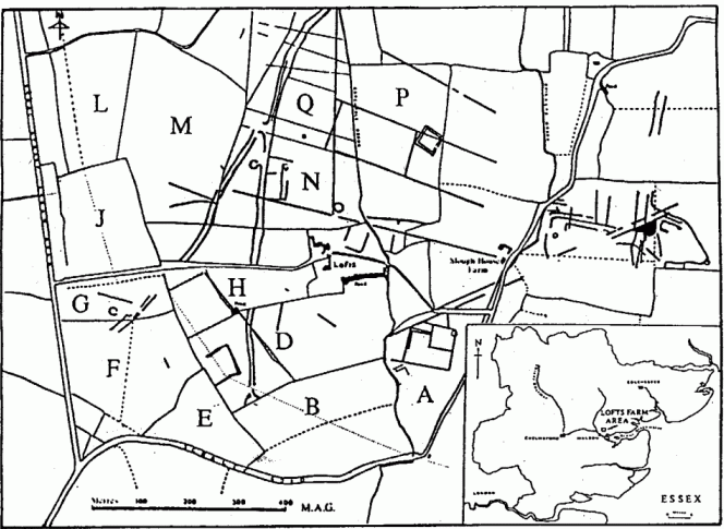
Over the years the gravel of "Lofts" has provided us with a microcosm of British history and prehistory. The initial aim of basically dating the crop marks has already been surpassed and a valuable contribution can be made to Essex archaeology generally when all the results have been published.
Animal life in pre-glacial times has been represented by fragments of a mammoth tusk found deep down in and below the natural gravel terrace. The Mesolithic hunters and gatherers have left us a scatter of flint tools and it is logical that many of identified silty patches in the gravel surface, whether caused by man, animal or plants, belong to these five or so millennia.
The pottery, cooking holes, flint and length of a ditch of the Neolithic "first farmers" gives a hint of sophistication in these peoples' lifestyle over their forerunners. Even greater sophistication is seen in the Bronze Age with its 'Barrow' burials, wells, double-ditched enclosure and huts.
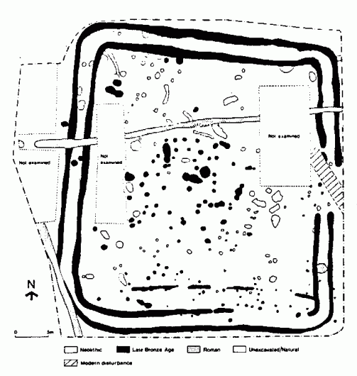
The period to provide the most graphic record of the time has been the Iron Age. Over hundreds of years, we see a succession of small farming settlements, their roundhouses, wells, enclosures, fields and granaries (four-posters) linked together by gently curving trackways. In addition to a wide range of Iron Age pottery, we recovered triangular loom weights, a spindle whorl and a small hoard of bronze objects. The succession of settlement had ended before the Romans superimposed an extensive system of small rectangular fields, modifying existing trackways and field entrances to suit their systematic land management.
The last phase of the Roman field ditches can be seen to have naturally silted up. The disappearance of the field system during the Saxon 'Dark Age' provides negative evidence for a different people with a different method of land utilisation.
The most recent field layout has developed piece-meal from the medieval period which is best represented by a rectangular moated site of the l3th century. Ironically, post-medieval changes in the landscape are more difficult to detect but I suspect a radical change in the middle of the 18th century. I hope documentary evidence may resolve this problem someday.
There is still much work to be done with the processing of the pottery from hundreds of prehistoric contexts and not until this is complete will we be able to understand the importance of our contribution.
We are indebted to Contractors Aggregates for allowing us to work on the site and also to the all-important co-operation of farmers Mr. Hughes, Mr. Rees and Mr. Goodwin. The discoveries have come as a result of many man/weeks of effort by Maldon Archaeological Group members and friends aided now and then with generous portions of luck. Grants towards the work have been received from Essex County Council, Maldon District Council, Contractors Aggregates, Lloyds Bank and British Telecommunications.